
LiDAR Surveying Services
Across Alberta, BC, and Yukon
0.05 and 1 meter Bare Earth Point clouds for Engineering, Mining, Construction and Environmental projects.
LiDAR Surveying in Alberta, British Columbia, and Yukon: Precision in Every Detail
LiDAR (Light Detection and Ranging) surveying has become a game-changer in the world of geomatics, providing unprecedented precision and efficiency for large-scale mapping and terrain modeling. At PCI Surveys, we specialize in offering LiDAR surveying services across Alberta, British Columbia, and the Yukon, harnessing this cutting-edge technology to serve the needs of the construction, mining, and environmental sectors.
Why Choose LiDAR for Your Surveying Needs?
LiDAR technology uses laser pulses to capture detailed, high-resolution data of the Earth’s surface. This data is invaluable for creating 3D models, topographical maps, and precise measurements of land features. With LiDAR, we can gather accurate information even in densely forested or hard-to-reach areas, providing you with the data you need for your project without compromising on quality.
Bare Earth Point Clouds: Accuracy at Every Scale
One of the significant advantages of LiDAR technology is its ability to generate bare earth point clouds. These models strip away vegetation, buildings, and other surface features to reveal the true topography beneath. PCI Surveys provides bare earth point clouds with varying resolutions depending on your project’s needs:
- 0.05 Meter Point Clouds: Ideal for projects requiring an extremely high level of detail, such as construction site planning, floodplain mapping, or archaeological surveys. These ultra-fine models capture subtle changes in terrain, ensuring nothing is overlooked.
- 1 Meter Point Clouds: These are well-suited for larger-scale projects such as infrastructure planning, mining, or environmental studies where detailed overviews of extensive areas are necessary, while still offering high levels of precision.
By customizing the resolution of the point clouds, we ensure that you receive the most appropriate data for your specific application—whether you need to monitor slight variations in elevation or map out large tracts of land quickly.
Benefits of LiDAR Surveying
- High Accuracy: LiDAR delivers precise data, essential for construction projects, mining operations, and environmental monitoring.
- Rapid Data Collection: Large areas can be surveyed quickly, reducing project timelines and allowing for more efficient planning.
- Versatility: Whether you need terrain mapping, flood modeling, or forest analysis, LiDAR is adaptable to a wide range of applications.
- Cost-Effective: By reducing the need for manual data collection and minimizing delays, LiDAR helps keep project costs down.
- Minimal Environmental Impact: LiDAR can collect data from the air, reducing the need for ground-based surveying teams and limiting the environmental footprint of your project.
LiDAR Applications in AB, BC, and YT
Our team at PCI Surveys is experienced in providing LiDAR surveying services across a variety of industries throughout Alberta, British Columbia, and Yukon. Some of the most common applications include:
- Construction Site Planning: LiDAR data helps identify potential risks, optimize site layouts, and ensure projects stay on schedule.
- Mining Exploration and Operations: Detailed 3D models of mine sites allow for more efficient resource extraction and better safety planning.
- Environmental Impact Studies: LiDAR aids in monitoring terrain changes, assessing deforestation, and modeling watersheds for environmental assessments.
PCI’s Expertise in LiDAR Surveying
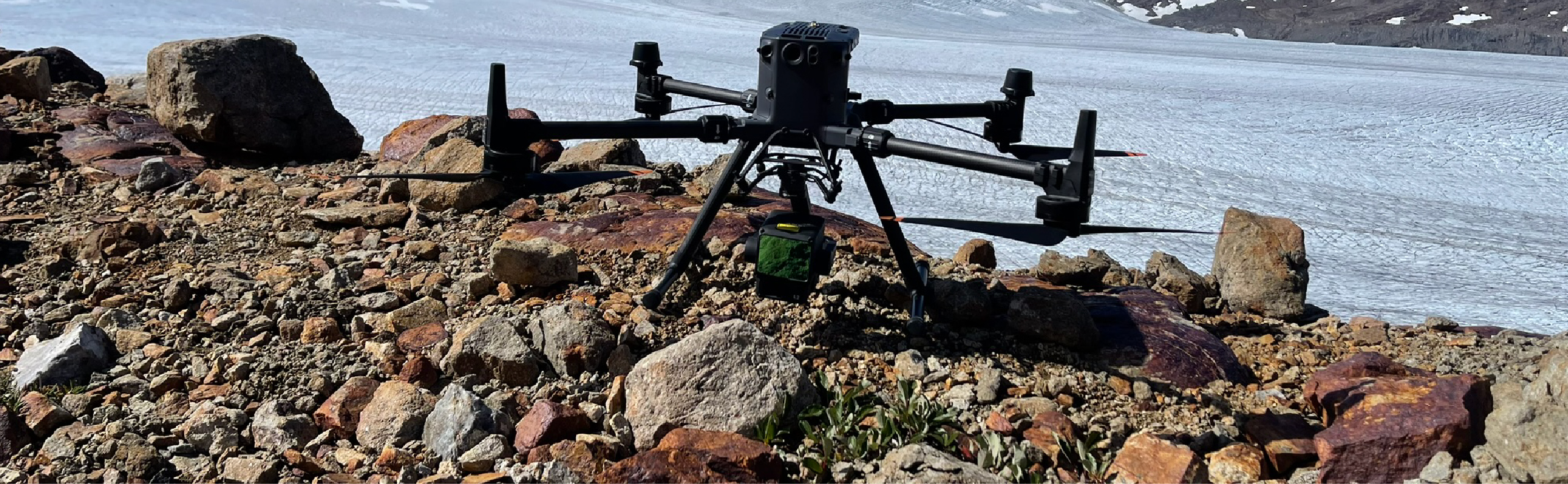
Our expertise in geomatics, combined with advanced drone technology and state-of-the-art LiDAR systems, enables us to deliver fast, accurate, and reliable results. Whether your project is in the bustling construction hubs of Alberta, the remote landscapes of British Columbia, or the challenging terrains of Yukon, our LiDAR services are tailored to meet your specific requirements.
Get in Touch
At PCI Surveys, we’re committed to delivering precision and excellence in every survey we conduct. Contact us today to learn more about how our LiDAR surveying services and bare earth point clouds can support your project in Alberta, British Columbia, or Yukon.